
Vaisala Xweather Solar Model 3 delivers industry-leading accuracy for renewable energy site historical evaluation and real-time performance monitoring.
Global Horizontal Irradiance (GHI) is one of the most critical factors for determining the production value of a solar installation. Satellite-derived GHI estimates have consistently outperformed ground-station measurements, especially at sites more than 25 km from the nearest station. That’s why Xweather’s solar irradiation data products, built upon our proprietary renewable energy solar irradiation database, benefit from the new satellite-based Vaisala Xweather Solar Model 3 - an advanced extension of the Vaisala 2.1 and HelioClim-3.
Reshape your project financing with breakthrough GHI accuracy
Xweather Solar Model 3 incorporates advancements from the Heliosat-V methodology to deliver higher accuracy and near real-time monitoring. The new model offers enhanced spatial consistency and accuracy worldwide, setting a new benchmark for bankable, high-resolution solar resource data. With this model, we achieve GHI accuracy improvements of up to 50% in bias standard deviation compared to other models, an invaluable enhancement for both pre-construction site location evaluation and project performance monitoring.
For context, a 1% reduction in uncertainty (GHI bias standard deviation) translates to a 0.5–1% increase in allowable debt sizing. On a $100M solar project, that's $500K—$1M in additional financeable debt.
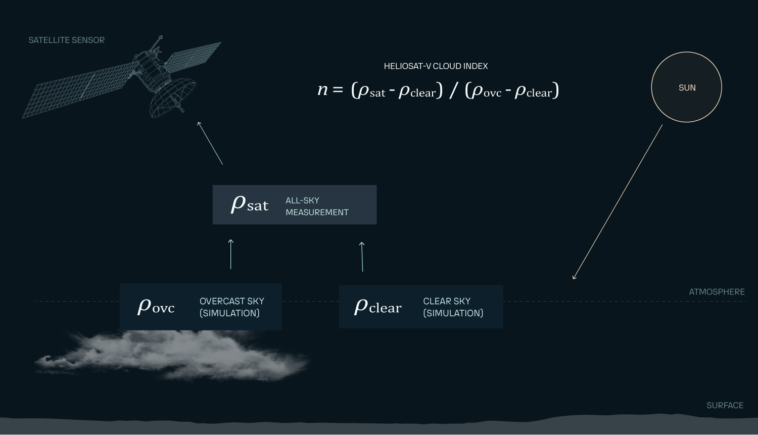
Xweather Solar Model 3 methodology
Xweather Solar Model 3 uses the Heliosat-V method, a new approach for retrieving GHI from an array of satellite instruments sensitive to reflected solar radiation aboard geostationary satellites. Heliosat-V is part of the family of “cloud index” methods. The cloud index is a widely used proxy for effective cloud transmissivity; it uses simulations from a fast radiative transfer model to estimate Earth reflectances for overcast and clear-sky satellite scenes.
The Xweather Solar Model 3 database is currently generated from Meteosat 0° satellite imagery. It has been compared to 66 locations where high-quality in situ measurements of GHI are available from the Baseline Surface Radiation Network (BSRN), the EnerMENA Meteorological Network in the MENA Region, the validation dataset of the IEA PVPS, the Energy Sector Management Assistance Program (ESMAP), the SAURAN national program in South Africa, and the Brazilian National Institute for Space Research INPE.
The Xweather Renewable Energy solar irradiation database combines a clear‑sky baseline with a satellite‑derived cloud index:
McClear clear-sky baseline: Establishes theoretical GHI under zero-cloud conditions for any latitude/longitude.
HelioSat-V:
Processes 15-minute geostationary satellite imagery (3km resolution)
Estimates overcast and clear-sky reflectance with surface/atmospheric anisotropy correction
Adapts to sensor-specific spectral sensitivity
Calculates cloud index without needing multi-spectral bands or per‑pixel history, streamlining the transition from MSG to MTG
Global horizontal irradiance is obtained by modulating the clear‑sky irradiance with a function of the cloud index.
The long-term database is computed from historical geostationary imagery to ensure temporal consistency.
Validation results
The results from Xweather Solar Model 3 and ground-based measurements show a mean bias error (MBE) of 0.86%, a bias standard deviation of 2.72%, an hourly mean absolute error (MAE) of 9.84% and an hourly root mean square error (RMSE) of 15.06%.
| Xweather Solar Model 3 | HelioClim-3 | Vaisala 2.1 | CAMS Radiation Service | |
|---|---|---|---|---|
| # of sites | 63 | 63 | 196 | 63 |
| Mean bias | 0.86% | 1.38% | 1.20% | 2.31% |
| Bias standard deviation | 2.72% | 3.97% | 4.09% | 3.87% |
| Mean hourly RMSE | 15.06% | 17.05% | 19.94% | 16.82% |