Forest fires can have devastating consequences on the environment and human health. They destroy wildlife habitats and communities, release greenhouse gases, and affect the quality of the air we breathe. According to the World Health Organization, exposure to smoke from forest fires can cause respiratory problems, cardiovascular disease, and premature death.
These health impacts are one of the many reasons why accurate, timely air quality data is crucial — especially during wildfire season. Air quality data monitors pollutant levels and provides us with measurements on specific pollutants, helping us forecast future air quality trends to inform the public about health risks and preventive measures.
How forest fires affect air quality
Forest fires produce large amounts of smoke, which is a complex mixture of gases and particles. The composition and concentration of smoke depend on several factors, such as type and amount of fuel, weather conditions, fire intensity, and distance from the fire itself. Smoke is comprised of a number of components, the main of which include:
Particulate matter (PM): These are tiny solid or liquid particles that can be inhaled and penetrate deep into the lungs. PM can vary in size, shape, and chemical composition. The most common and harmful types of PM are PM2.5 and PM10, which have a diameter of less than 2.5 and 10 micrometers, respectively. PM can cause irritation, inflammation, and damage to the respiratory system, as well as increase the risk of asthma, chronic obstructive pulmonary disease (COPD), lung cancer, and cardiovascular diseases.
Ozone (O3): This is a gas that forms when nitrogen oxides (NOx) and volatile organic compounds (VOCs) react with sunlight. O3 is a powerful oxidant that can damage the cells lining the airways, causing coughing, wheezing, shortness of breath, and reduced lung function. O3 can also aggravate existing respiratory conditions, such as asthma and COPD, and increase the susceptibility to infections.
Nitrogen dioxide (NO2): This is a gas that is emitted by combustion processes, such as forest fires, vehicles, and power plants. NO2 can irritate the eyes, nose, and throat, and cause respiratory infections, bronchitis, and asthma. NO2 can also contribute to the formation of O3 and PM.
Carbon monoxide (CO): This is a colorless, odorless, and tasteless gas that is produced by incomplete combustion of organic materials, such as wood, coal, and gasoline. CO can reduce the oxygen-carrying capacity of the blood, leading to headaches, dizziness, nausea, fatigue, and impaired mental function. CO can also worsen cardiovascular diseases, such as angina, arrhythmia, and heart failure.
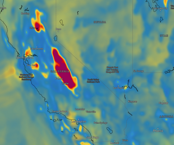
The effects of smoke on air quality can vary depending on the location, duration, and intensity of the fire, as well as the meteorological conditions, such as wind, temperature, humidity, and precipitation. Smoke can travel long distances and affect regions far from the fire source. Smoke can also interact with other pollutants to create so-called secondary pollutants. The impact of smoke on air quality can last for days, weeks, or even months after the fire is extinguished.
Challenges in air quality measurement and forecasting during fire events
Measuring and forecasting air quality during fire events is complex and carries multiple challenges. Among these:
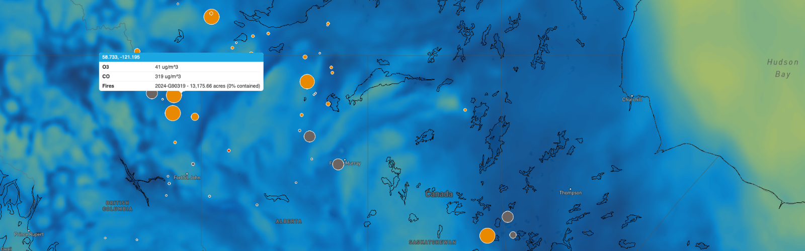
Lack of data: Publicly available air quality data is collected from a network of ground-based monitoring stations for the locations available. However, some areas affected by forest fires — especially remote or rural regions —do not have enough ground-based monitoring stations, creating a coverage gap. Moreover, monitoring stations become susceptible to damaged or inaccessibility during fire events, resulting in additional data gaps and delays. Satellite observations provide some complementary data to fill these gaps, but these observations have limitations in terms of spatial and temporal resolution, cloud cover, and retrieval algorithms.
Lack of models: Too few numerical models can simulate the physical and chemical processes of fire emissions, transport, and transformation. Even with the models available, some may have biases or errors in representing the meteorology, land cover, fire behavior, and emission factors. These models also need to be validated and calibrated with observational data, which — as previously mentioned — may not be accurate (or even available).
Lack of communication: More effective, efficient ways of communicating air quality data, forecasts, and risks to the public are needed — especially during emergency situations. To ensure that the public understand the meaning and implications of critical air quality information, it must be available in numerous formats, frequencies, and units, and put into relevant context for the viewer or listener.
Take action with reliable air quality data
Vaisala Xweather uses proprietary technology to combine unique measurement data from local sensors with cutting‑edge AI models to provide the most accurate, timely, and actionable weather insights, turning weather data into your advantage. Our insights provide reliable and actionable air quality information to our customers, especially during fire events. Some of the features and benefits of our services are:
Comprehensive data: We combine data from multiple sources, such as reference grade stations, Vaisala air quality transmitters, satellites, and fire reports to provide a comprehensive and up-to-date picture of the air quality situation. This data undergoes advanced quality control and assurance to ensure its the accuracy and consistency.
Advanced models: Our cutting-edge models simulate the complex dynamics of fire emissions, transport, and transformation. We also use machine learning and artificial intelligence techniques to improve the performance and accuracy of the models, which are constantly updated and refined with the latest data and research.
Effective communication: Our air quality datasets, visuals, and alerting capabilities are built with communication in mind. Create full-scale weather maps demonstrating air quality risks with components in easy-to-understand color scales, build API responses built to return only what you need, or set up automated air quality alerts when critical locations are at risk. We also strive to make weather data universally understandable: Air Quality Health Index (AQHI) is a key feature of our air quality portfolio, providing a scale that measures the health risk associated with the air pollution level
Forest fires are a serious threat to both the environment and human health. Coping with this challenge requires accurate, timely current and forecast air quality data — especially during fire events — to help you breathe better and live healthier.