Without formal pavement or signage data, Lauderdale County lacked a foundation for data-driven planning. RoadAI changed that—bringing structure, precision, and accountability to every mile.
Faced with aging infrastructure, subjective road selection, and limited funding, Lauderdale County, Tennessee, turned to RoadAI to bring objectivity and clarity to its resurfacing strategy. With support from local planners and engineers, the county now uses granular condition data and visual insights to plan smarter and make the case for long-term investment.
Challenge: A need for structure, justification, and transparency
When Derek Kissell transitioned from the Tennessee Department of Transportation (TDOT) to become Highway Superintendent for Lauderdale County, he noticed a glaring gap: data.
“Coming from TDOT, we had a full pavement management system. But here, we were just picking roads to pave based on what looked worst,” Kissell said. “I knew we needed something more objective—something to take the politics out of the process.”
Before RoadAI, the county had no formal pavement condition data or sign inventory. Road selection was based on visual inspection and experience—a method that is practical but vulnerable to influence and inconsistency. Kissell knew that without data, it was difficult to justify funding or explain priorities to stakeholders.
The county needed:
Road condition scoring to prioritize paving
Sign inventory for federal compliance
Visual documentation to support reimbursement and grant requests
Transparent data to reduce political influence in decision-making
Making the case for smart spending
Adopting new technology wasn’t without challenges. Proposing software to a rural county’s budget or highway committee raised initial concerns—especially as some competitors quoted over $200,000 just to analyze state aid roads.
“We couldn’t afford $200,000 for some of the larger solutions,” Kissell said. “RoadAI gave us the data we needed without breaking the budget.”
“We couldn’t afford $200,000 for some of the larger solutions. RoadAI gave us the data we needed without breaking the budget.”
Derek Kissell, Highway Superintendent - Lauderdale County
With most county roads seeing fewer than 300 vehicles per day, RoadAI’s affordability and targeted functionality made it the right fit. Lauderdale held vendor demos and selected RoadAI as the most scalable and cost-effective option.
“We're very rural,” Kissell added. “RoadAI provides the right level of detail for our needs, without the overhead.”
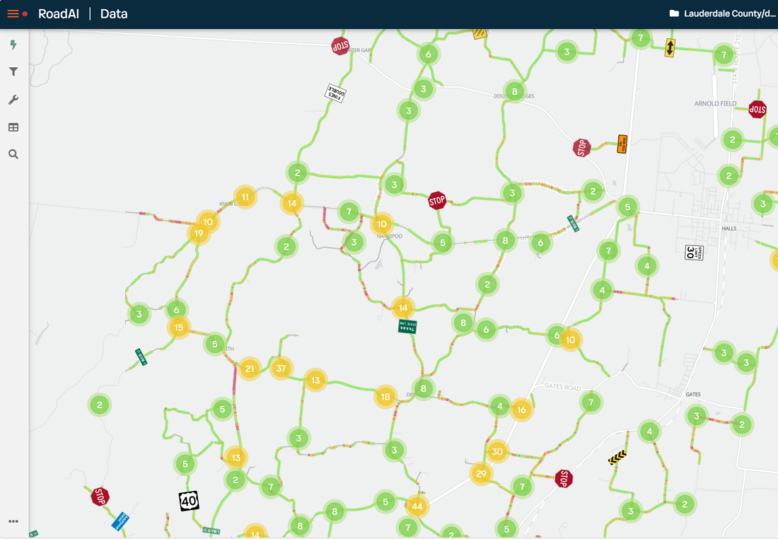
Lauderdale County can see the direct impact of chip seal treatments on road surface condition scores, using RoadAI to record data before and after maintenance. This helps justify funding for specific treatments.
Solution: A data-driven resurfacing plan with RoadAI
With support from Economic Development Specialist, MidSouth Development District Karyssa Wilson, Lauderdale County deployed RoadAI to:
Collect surface condition scores across the network
Identify distressed segments and pinpoint failure types
Inventory roadway signage
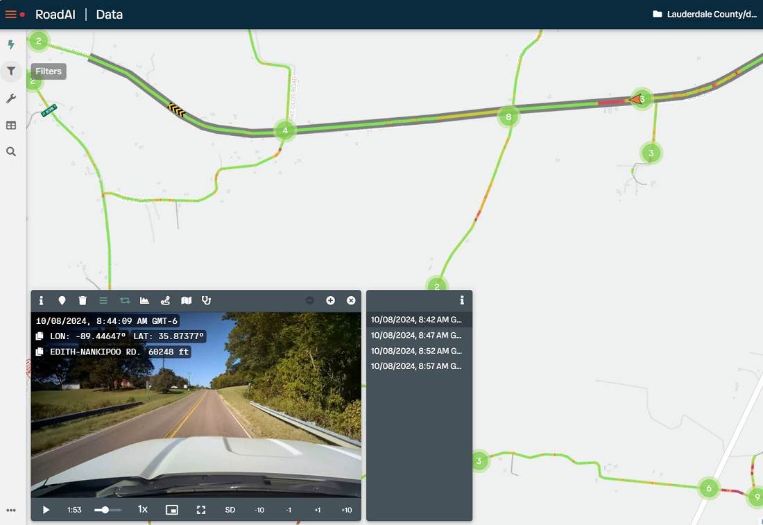
Capture visual evidence for grant submissions and FEMA reimbursement
Wilson took the lead in building a resurfacing priority plan from RoadAI’s data. The platform’s intuitive interface made onboarding easy, but the true challenge lay in tailoring the data for local decision-making.
“There were so many different ways you could pull the data—it was overwhelming in a good way,” Wilson said. “I wanted to make something Derek couldn’t easily do on his own. RoadAI gave me the tools to do that.”
"There were so many different ways you could pull the data—it was overwhelming in a good way,”
Karyssa Wilson, Economic Development Specialist - MidSouth Development District
She enhanced the rankings by layering in roadway geometric data from TDOT—especially horizontal and vertical alignment, which are key contributors to rural road safety risk. Because Lauderdale resurfaces full road segments (not isolated patches), she broke long roads into smaller scoring intervals to avoid misrepresentation. This approach preserved both the macro picture and the granular reality.
“When you zoom out, it looks like there are a lot of distressed segments,” she said. “But zoom in, and you see the true condition. That level of detail is what made the plan reliable.”
RoadAI gives Lauderdale County continuous insight into the condition of their network, enabling them to address issues early and "keep their good roads good."
Impact: Confidence in every mile
Since adopting RoadAI, Lauderdale County has seen meaningful shifts in both process and outcomes:
Standardized road selection. RoadAI scores now guide resurfacing plans based on need, not opinion.
Improved pre-paving preparation. Crews address structural failures in advance rather than overlaying problem areas.
Stronger documentation. Photos and videos help track storm damage and support FEMA or TDOT requests.
Sign inventory accountability. The county now tracks sign locations and damage, meeting federal compliance more easily.
“It gives me hard data to explain why this road and not that one,” Kissell said. “That takes politics out of it.”
Wilson agrees: “Without RoadAI, I wouldn’t have been able to make the plan. The data’s not just granular—it’s trustworthy and consistent.”
“Without RoadAI, I wouldn’t have been able to make the plan. The data’s not just granular—it’s trustworthy and consistent.”
Karyssa Wilson, Economic Development Specialist - MidSouth Development District
Laying the groundwork for future funding
While RoadAI hasn’t yet led to a direct increase in Lauderdale’s road budget, the groundwork is there. Political and economic factors have capped short-term funding, but the county is now positioned to make a stronger case moving forward.
A one-time TDOT allotment provided temporary relief for state aid paving. While not directly linked to RoadAI, Kissell emphasized that condition data helped Lauderdale stand out among peer counties. More locally, the data directly influenced the county’s approval to convert several residential chip seal roads to asphalt—projects that were justified using RoadAI scores and video.
“These roads were in subdivisions with low-weight vehicles and no heavy truck traffic,” Kissell said. “With the right investment, they could last 30 to 40 years.”
Beyond budgets, RoadAI is reshaping how decisions are made. In small counties, resurfacing choices often rest with a single official. “That process can be politically influenced,” Kissell acknowledged. “But now we can say, ‘Here’s the score. Here’s why this road was picked—and why another wasn’t.’”
He puts it plainly: “If you want to take the politics out and show your work—RoadAI’s the way to do it.”