
Improve
ODD boundary detection
Real-time
data updated every 15 minutes
Millions
of kilometers of roads covered globally.

Safer autonomous driving in adverse weather
Every fifth road accident is weather-related. Assisted and autonomous driving systems could prevent many of these accidents, but only if system designers can create systems that operate safely and reliably in adverse weather conditions.
Xweather helps automotive innovators enable AV systems in a broader range of driving conditions by providing probabilities for water, snow, and ice on the road surface. The data provides real-time information for public paved roads, updated at 15-minute intervals, along with a two-hour prediction.
With Xweather, carmakers can expand AV sensing capabilities, improve safety, and increase the availability of their automated systems.
Expand operational limits
We help the industry safely extend the weather-specific operational design domain of autonomous driving systems. Our driving conditions data improves systems and helps identify routes suitable for autonomous driving.
Improve safety and performance
Vehicle sensors struggle to detect changing weather and road conditions due to limited range and reduced performance in adverse weather, posing safety risks to assisted and autonomous driving systems. The Xweather Road Weather Service provides real-time road surface and weather data beyond the sensor range and predicts phenomena not detectable by vehicle sensors. Our data serves as a virtual sensor with an infinite range.
Fleet management
Road weather data enables better route planning and operational efficiency by predicting hazardous conditions ahead of time, allowing fleet managers to optimize routes and manage autonomous vehicle deployment more effectively.
Explore road weather
See critical road and atmospheric weather conditions for autonomous vehicles along selected routes.
Road weather expands automated vehicle systems to function reliably in a wide range of driving conditions.
Xweather AD/ADAS parameters
Our data provides access to high-resolution parameters built for advanced applications, with all available via a single API endpoint for streamlined development.
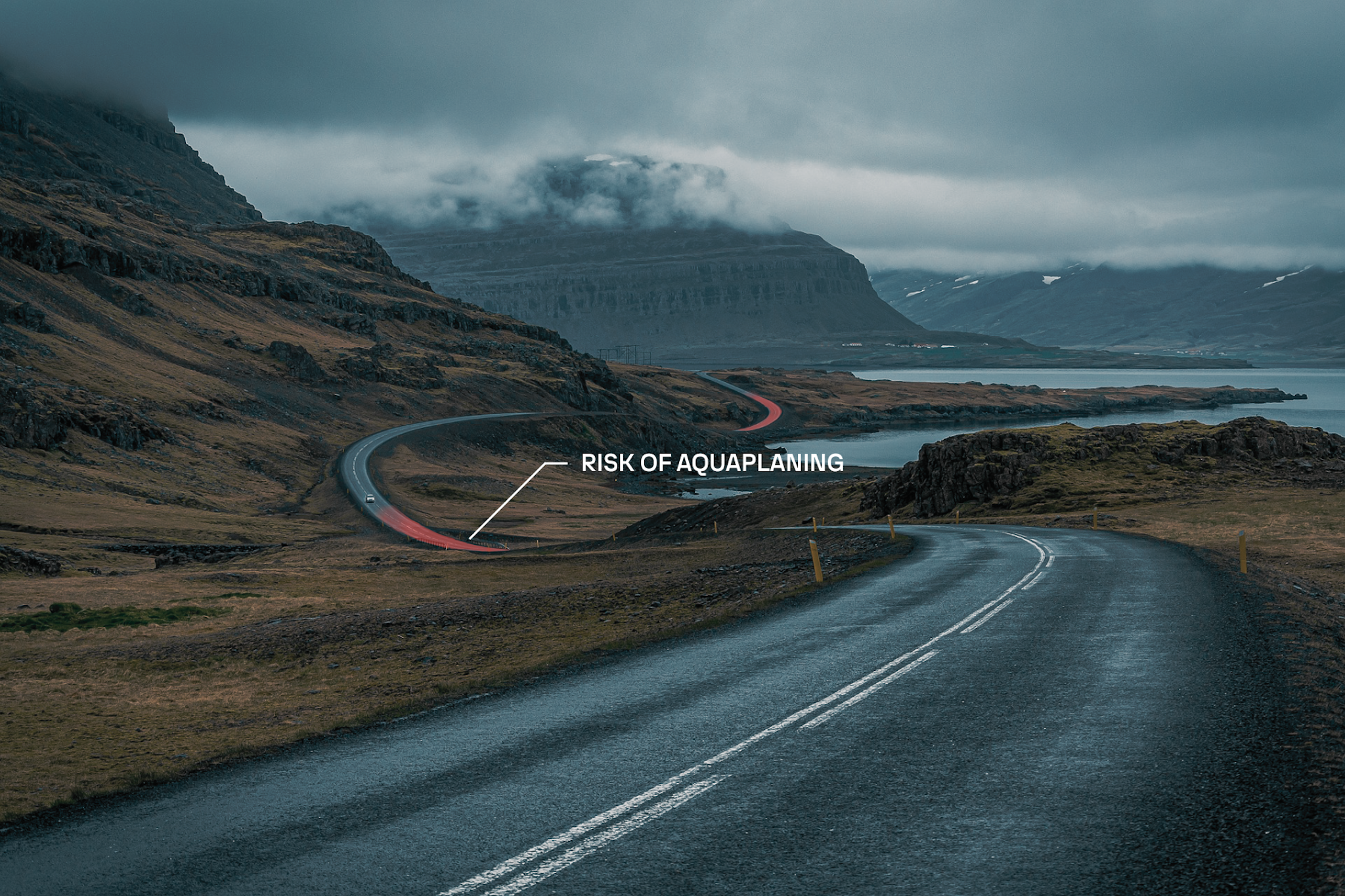
Road weather conditions
Slippery roads affect AV safety, directly impacting traction, braking distances, and vehicle control. Wet, snowy, or icy surfaces require immediate adjustments to driving speeds, following distances, and may trigger transitions to more conservative operational modes or human handover requests. Xweather Road weather data delivers real-time and forecasted probabilistic and layer thickness data on water, snow and ice on the road.
Wind speed and direction
Wind speed and direction are critical parameters for AV systems, affecting vehicle stability control, trajectory planning, and safe operation of autonomous vehicles, particularly for larger autonomous delivery vehicles and trucks. Xweather reports wind speed and direction at 2 meters altitude, rather than the 10-meter standard wind, and provides probability of winds causing truck blow-overs to support safety assessments for high-profile vehicles.
Low visibility
Low-visibility conditions caused by fog, heavy precipitation, or blowing snow severely compromise AD/ADAS sensor modalities, significantly reducing detection range and object recognition accuracy. Accurate low-visibility data and forecasts enable autonomous systems to make proactive decisions about route selection, operational mode transitions, and whether conditions allow continued autonomous operation.
Severe weather conditions
Severe weather events such as lightning, hail, and tornadoes pose critical safety risks to passengers and vehicles and can result in the immediate suspension of autonomous fleet operations. Xweather's severe weather endpoints provide real-time and historical data, along with threat zones for lightning, hail, and tornadoes, through a single API.
Precipitation
Heavy precipitation reduces visibility and impacts road surface conditions, reducing tire traction and increasing stopping distances, which requires adjustments to following distances and speed limits.

Significant increase for autonomous vehicle system availability
Road weather data significantly improves the availability of AV systems compared to relying solely on vehicle temperature sensors. Vehicles using road weather data experience autonomous-driving feature deactivations only 10% of the time annually, while those relying strictly on onboard temperature sensors experience deactivations 20.4% of the time.
Automotive-grade partner
With over 25 years of experience working with roads and automotive customers, Xweather offers industry-leading SLAs and KPIs, all backed by robust automotive-grade incident management processes.
Trusted by industry leaders
Leading carmakers choose Xweather to improve the safety, efficiency, and sustainability of mobility. Xweather provides data for infotainment weather applications, EV range predictions, driver warnings, and ADAS & AD friction prediction.
Machine readable and validated
Xweather offers a reliable, ready-to-use solution that runs parallel predictions combining the results into a probability distribution that exposes the uncertainty of the future predicting. The data is validated against ground-truth measurements for water, snow and ice.
Millions of kilometers of roads covered
Vaisala Xweather's Road Weather data covers millions of kilometers of roads in North America, Europe, Japan, Australia, and New Zealand. We model primary and secondary roads separately to reflect the effects of different road surfaces, traffic levels, and maintenance priorities. Bridges are also modeled separately to account for the free flow of air beneath the road surface.
Unlike fleet-sourced data, which often has significant spatial and temporal gaps, our Road Weather data delivers real-time conditions and forecasts for every public paved road 24 hours a day, 365 days a year.

Want to know more? Get in touch with our experts.
Whatever your road weather needs, we’re here to help. Get in touch today, and let us put our expertise to work for you.