New tools streamline post-storm forensic analysis for power utilities and wind farm operators
After a storm passes, you need to understand its impact. Was a fault or outage caused by lightning? Which assets should you prioritize for inspection?
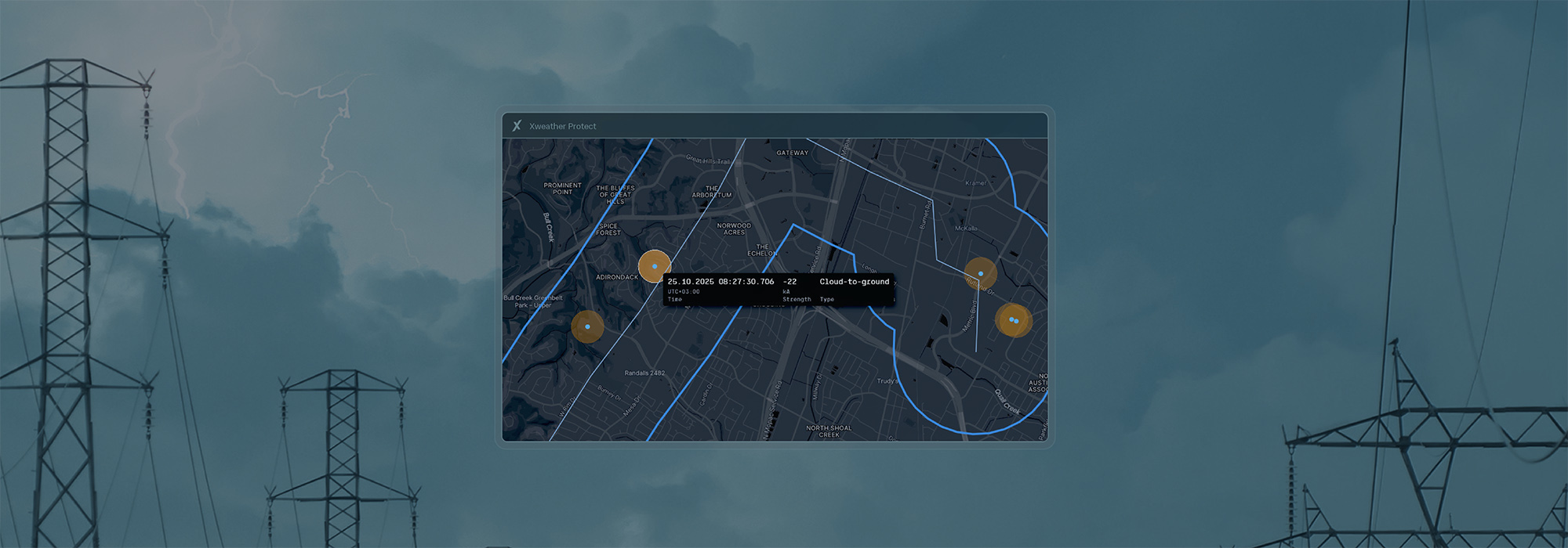
Xweather Protect provides data from 2016 to the present on lightning events within 1–150 km of your assets. You can generate a report in seconds, then view the results on an interactive map, or export the data as a CSV, JSON, or GeoJSON file for use in your own tools.
Our latest update adds location confidence ellipses for every strike, strike damage potential ratings, and new report filtering options. These improvements help reliability engineers and operations teams build stronger correlations between equipment failures and lightning activity, reducing guesswork and focusing field resources where they're needed most.
What's new
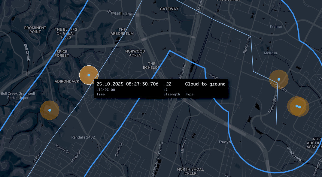
This Xweather Protect report shows multiple lightning strikes near a high-voltage transmission line. Error ellipses identify strikes that may have hit the line. Event timestamps, accurate to the millisecond, let you correlate faults with a specific strike to determine which towers and spans to inspect.
Error ellipses for every strike
The Xweather Lightning Network pinpoints the location of lightning strikes worldwide with incredible accuracy. Error ellipses show you the confidence region around each strike, helping you prioritize assets for inspection. You can select your preferred confidence level—50%, 80%, 90%, or 99%—then view the ellipses on the map or export the data to your GIS tools for further analysis. These error ellipses, combined with precise timestamps that are accurate to the millisecond, enable you to confidently correlate faults with the time and location of lightning strikes.
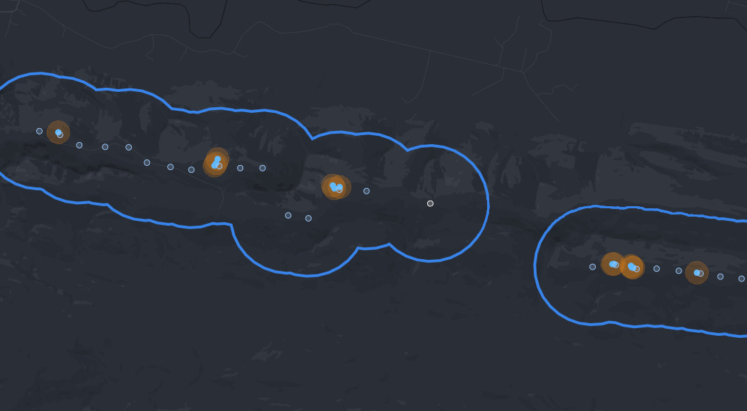
This Xweather Protect storm report shows 13 lightning strikes to 6 turbines on a wind farm in one 24-hour period. New filter options let you isolate positive polarity strikes or strokes above a specific kA threshold. With this data, farm operators know exactly which turbines to inspect for damage.
Streamline your workflow with new filters
A large storm can produce tens of thousands of lightning events across your service territory. New filter options help you isolate the strikes most relevant to your investigation.
You can now filter reports to show only cloud-to-ground events, or go further and show only positive strikes, which carry higher peak currents and greater damage potential. You can also isolate strikes above a specific kA threshold to identify events that exceed your protection equipment ratings.
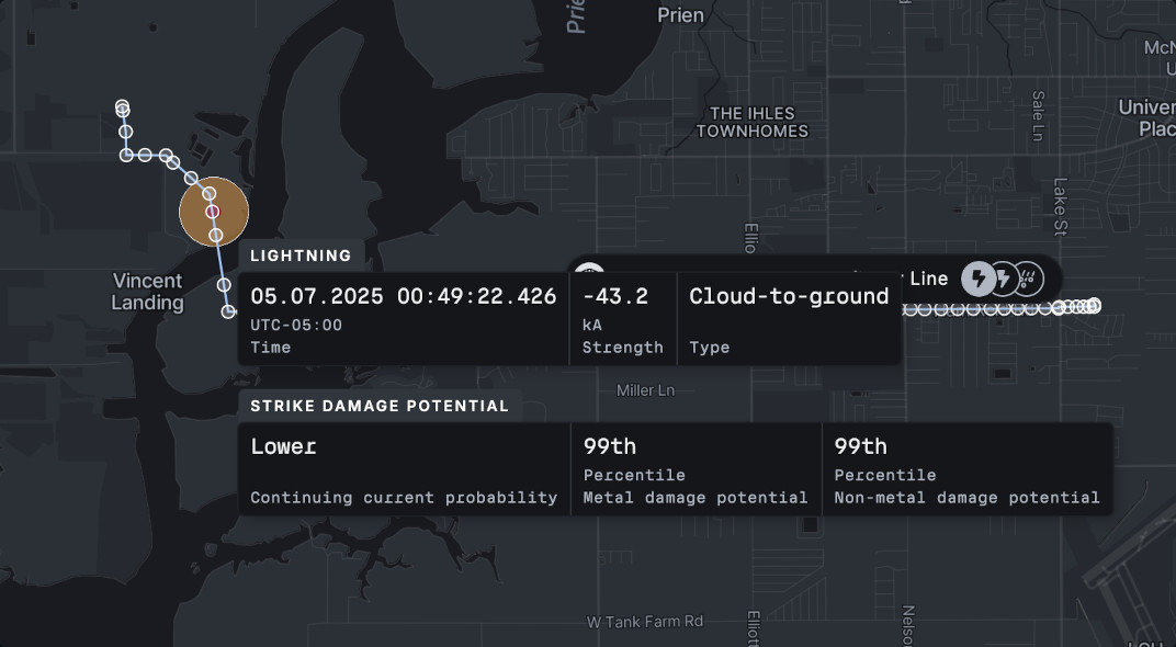
The strike damage potential feature, exclusive to Xweather, identifies and ranks strikes by their potential to damage structures and equipment.
See the strike damage potential
Reports now include strike damage potential ratings for each cloud-to-ground event. This innovation, exclusive to Xweather, identifies strikes with characteristics most likely to cause equipment damage: high peak current, long continuing current, or multiple return strokes.
The strike damage potential filter intelligently combines co-located strokes into single strike points, then ranks each strike by its potential to cause extreme heating damage based on its strength and the probability of continuing current.
Up to 31 days in a single report
You can now include up to 31 days of lightning activity in a single export. Pull an entire storm sequence for impact analysis. Build monthly or quarterly reports comparing current activity to historical averages. Prepare executive briefings documenting storm impacts across the billing cycle. The extended window eliminates the need to stitch together multiple exports and improves reporting efficiency.
Powered by the world's most accurate lightning data
Xweather Protect is powered by the Xweather Lightning Network, which detects the precise time, location, and characteristics of over 2 billion lightning events every year. Using proprietary sensors designed, manufactured, and monitored by Vaisala, the network identifies and classifies both cloud-to-ground and in-cloud lightning, pinpointing the location to within 100 meters in the U.S. and 1 km globally. This precision, combined with over 40 years of lightning detection experience, is why Vaisala is the primary source of lightning data for the National Weather Service, Federal Aviation Administration, U.S. Armed Forces, and hundreds of other businesses and organizations.
Severe weather safety before, during, and after the storm
Beyond the post-storm reporting tools we covered here, Xweather Protect also delivers real-time lightning alerts, wind and hail warnings, and comprehensive severe weather monitoring. Discover complete severe weather protection for your operations in one platform.