The Weather API provides a variety of severe weather-related endpoints you can use in your own applications to stay on top of threatening conditions. This guide details the key endpoints to help you handle seasonal weather challenges in any situation. The endpoints below are listed in alphabetical order with additional links to documentation.
alerts endpoint
The alerts endpoint provides access to all currently-active advisories across the US, Canada, and Europe, as issued by the National Weather Service (NWS), Environment Canada, and MeteoAlarm. for localized regions, counties, or forecast zones.
During severe weather season, the alerts endpoint is indispensable for obtaining critical tornado and severe thunderstorm watches and warnings. For tornado, severe thunderstorm, or flood warnings, the localized polygon of the area covered by the warning is also included.
convective/outlook endpoint
The convective/outlook endpoint provides access to convective weather outlooks issued by the Severe Prediction Center (SPC). Convective outlooks provide information on potential severe weather, including thunderstorms, tornadoes, damaging high winds, and hail. Coverage for this endpoint is currently available for the continental US only.
lightning endpoint
Our lightning datasets leverage data compiled from the world's most comprehensive lightning detection networks. The lightning endpoint provides the last 5 minutes of cloud-to-cloud and cloud-to-ground lightning strike data for anywhere across the globe. Return precise lightning strike stats including:
Amperage
Location
Polarity
Type of strike/pulse
lightning/threats endpoint
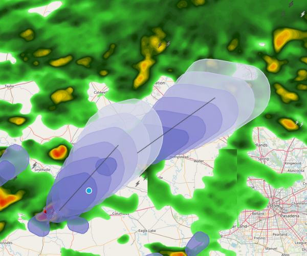
The lightning/threats endpoint provides access to lightning nowcasts, with up to 60 minutes of potential thunderstorm activity in 10-minute intervals to alert you when and where lightning strikes have the potential to occur. This data is imperative in decision-making applications to ensure the safety of people and assets and optimize operational uptime.
lightning/threats is available globally and leverages the same renowned lightning detection network as our lightning endpoint.
threats endpoint
The threats endpoint provides a localized summary of current and potential storm threats affecting or approaching a specified location while ignoring non-threatening storms and those that don't pose risk to the given location.
stormcells endpoint
The stormcells endpoint provides observed data and forecasts for individual storm cells across the United States. Our storm cell information is radar-derived and attempts to identify and track storm cell movement. Cell intensity and severe weather signatures within the cell, such as rotation and hail, are also reported. The forecast track can be obtained as either a polygon cone or a line, and can be used to query and determine when and where a storm cell will affect a particular location.
stormcells/summary endpoint
stormcells/summary provides a full-picture overview of current storm cells. You can use stormcells/summary to:
Obtain the total number of storms cells
Query the maximum hail currently reported within all storm cells
Query the number of storm cells with a high probability of hail within a 50-mile radius
Polygons of storm cell groups are also included in the summary, allowing you to plot clusters of storm activity on maps. Coverage area includes all US states, Puerto Rico, and Guam.
stormreports endpoint
Our storm reports endpoint provides access to local storm reports as transmitted by the National Weather Service (NWS). These reports provide information about severe weather events for a specific location and originate from storm spotters, such as amateur radio operators, storm chasers, law enforcement, emergency management, or curious and trained civilians.
The stormreports endpoint provides a storm data archive that dates from current day all the way back to the early 1900s.
This endpoint is perfect for finding and visualizing the total number of tornado and hail reports as active storms progress. Many reports will include additional details specific to the event, such as hail size, wind speeds, and precipitation amounts.
stormreports/summary endpoint
stormreports/summary provides a broad summary of storm reports that have been received based on search/filter criteria. Examples of the stormreports/summary endpoint in action include:
Obtaining the number of storm reports received within a timeframe and geographical area
Obtaining maximum rainfall or wind speeds reported from all reports
Obtaining the total number of tornadic storm reports within a 500-mile radius of a particular location
Severe weather season poses challenges, but that doesn't mean it needs to be unpredictable. Empower your business operations with severe weather data and start building your own weather confidence today.
Leveraging Xweather's severe weather API endpoints
Sold on the Xweather API being your weapon of choice this severe weather season? Access all of our endpoints and datasets with any Xweather API subscription, from our free trial to our Raster Maps-inclusive Flex plan. Get started today — we can't wait to see what you build.


