
Shawn Buckley has worked as the Supervisor of Transportation Infrastructure at the Region of Waterloo for the last 14 years. Prior to the Region, Shawn was involved with collecting pavement management data for agencies across Canada and the United States.
Thanks for meeting with us today Shawn. What is your role in the Region of Waterloo?
My role is on the planning side, where I’m primarily tasked with looking after the road network from a lifecycle point of view. To do this, I need to make sure I collect accurate data for the road sections, because a lot of that work is dependent on the condition of the road.
How has the Region of Waterloo handled road asset management before deploying RoadAI?
Our road condition surveys have traditionally always been done in-house. While this approach worked fine for the data side, the challenge was that we didn’t have any video associated with those surveys.
On the flip side, we did bring in a vendor a few times in the past to collect video log for us, which worked out fairly well. However, in those contracts, we were unable to include the pavement distress rating due to cost. At the end of the day, we either had a distress rating with no video, or video with no distress data. So then of course when RoadAI came along, we were intrigued by the claim that we could have both, that we could continue to collect our own data utilizing cell phone video, and the really cool part was that the distress rating happens automatically.
What was your experience getting the RoadAI system up and running?
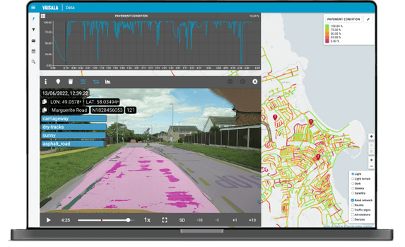
It’s quite easy to set up in the vehicle. You can set it up in the morning, in any vehicle, and take it away at night if needed. A couple of taps and you’re into collecting data. By the time you are back in the office, you can access the data through web portal, not just the video, but the pavement distress data as well, it’s color coded onto your pavement network.
What are the main benefits are you getting from RoadAI right now?
The first benefit we picked up on right away was ease of data collection. It’s very simple. The second main benefit was the very quick visual overview of our road network through the use of heatmaps. You can select the heatmap that summarizes all the distresses into a condition index, or you can select a heat map for a specific distress. Another benefit was the ability to export the pavement distress data into various formats. As an example, we have been experimenting with the data export to Excel function. For those who are really interested in the data, it’s good that it’s great to know that it is available and not locked away in a black box.
Before RoadAI, how much of your network would you survey each year?
Before RoadAI, it would take us about four to six weeks with two people in the vehicle. Because of that, we changed the data collection cycle to collect only half of the network each year.
Now with RoadAI, how much of your network are you able you survey?
In the one data collection cycle we've had with RoadAI, we collected our entire network in just over two weeks, and keep in mind this is now only with one person. So we required half the man power, and it took us about a third to half the time it normally would to collect the whole network.