)
Before we explore MapsGL for enterprise risk management applications, let’s address the root question: What is WebGL technology? WebGL’s technology involves a process of encoding data, which is then deciphered through an SDK by an end device. This decoded data is then displayed as imagery – in our case, weather maps – using the powerful GPUs found in most mobile and desktop devices. This visualization strategy allows us to flip the mapping paradigm on its head by delivering data that can be endlessly altered and interpolated, versus static images which need to be continuously updated as the user pans/zooms and animates.
To help new users and developers get familiar with the MapsGL platform, we have built a number of the features into our demo applications, and for those who are hands-on learners, we’ve enabled MapsGL in our 30-day developer trial. We also encourage you to explore our robust MapsGL documentation and follow this blog series highlighting what makes MapsGL unique and what types of deployments (use cases) it shines in.
Enterprise risk management
If you’re seeking opportunities to improve your enterprise’s risk management strategy, look no further than MapsGL. With animations and features to take weather awareness to the next level, the MapsGL SDK provides endless options for custom weather visuals that center around the needs of your enterprise.
Fixed + mobile assets: Monitoring weather risks
Enterprise risk management is a broad category that includes everything from protecting individual assets like vehicles or machines to on-site maintenance such as snow and ice removal. Power lines, data centers, retail locations, truck fleets, wind farms, solar panels, warehouses – whether your most critical assets are fixed or mobile, one thing’s for certain: you want to actively monitor any risk to them. Weather mapping brings a fresh perspective into your risk management strategy, allowing you to contextualize weather impacts.
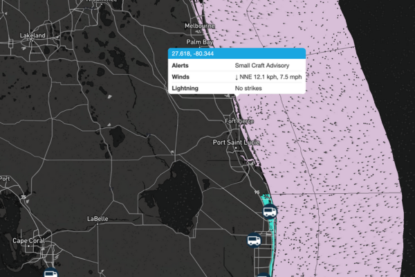
Track fixed and mobile assets in real-time with weather context.
Visuals
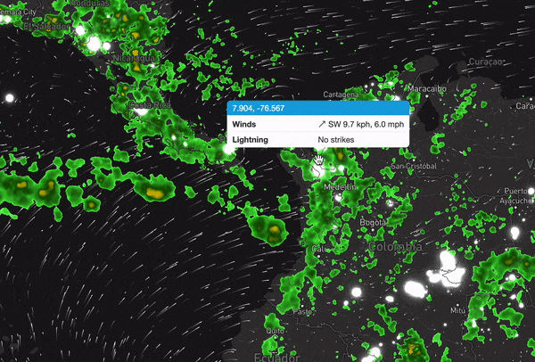
A common approach is to centralize remote asset monitoring in either a Network Operation Center (NOC) or business-wide virtual dashboard. This allows team members to prepare and act across all enterprise assets. With teams working in parallel, an intuitive visualization product is required to ensure all glean the same insights. Blending your existing mapping views with weather, using a simple JavaScript SDK, enables your team to continue to leverage the tools they have come to rely upon while expanding. Datasets such as radar, lightning, winds, and tropical cyclones updated in real-time with animation tell a clear story and pinpoint impact.
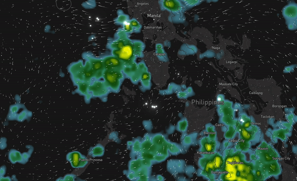
Customize visuals for anywhere in the world – including custom radar colorways and lightning shaders.
Speed
Every second counts when critical weather is afoot. MapsGL delivers real-time weather – such as active weather alerts, forecast radar, and live lightning – using fast low-bandwidth delivery methods to help with time-sensitive decisions to shut down locations, reroute mobile assets, and stage crews.
Employee safety: Ensure and enhance protocol
When the weather gets rough, obtaining access to the internet and the tools it provides access might not be an option. Providing your field teams with an option to keep them informed on weather events without internet access can empower your team to accomplish their goals wherever they happen to be – which is just as important as keeping them safe and connected in the field.
Access weather data any time – even without a network connection.
Low-bandwidth support
When critical infrastructure is at risk or down, enterprise resilience moves to now-jammed mobile networks. To ensure communication channels are maintained, low-bandwidth communication is required. MapsGL has an encoding feature allowing it to be both data-rich and low-bandwidth. This in turn allows field crews and remote team members to continue to have access to a full suite of insightful data, allowing them to make real-time decisions, keeping your employees safe and business operational while others may be losing speed or visibility altogether.
Visuals
The advanced nature of MapsGL’s visuals make it clearer than ever for users to understand when and where they will encounter severe weather. Allow your developer team to take the reins on customization: MapsGL’s customizable nature means that your weather maps can be altered to your liking, whether those adjustments include aligning with your business’s brand guidelines, application interface, or considerations to make inclement weather visuals accessible for all employees. No-load panning and zooming make scrolling the map a seamless process, and since the image is encoded, no additional calls are made to the API.
Enabling your business to quickly and effectively handle severe weather, MapsGL puts real-time, highly accurate weather data at the center of your weather emergency management initiatives. If you’re ready to make the switch from raster maps to our WebGL-enabled platform, our SDKs and Customer Success Team are here to assist in the process.
Follow along as we continue to release new use case breakdowns in this blog series. To learn more about the MapsGL SDK, reach out to us.
The use cases we’ve explored here are by no means exhaustive: We’re excited to help you put our latest offering to work for your audience.
Interested in learning more about MapsGL’s use cases? Check out the first blog in this series highlighting MapsGL’s effectiveness in consumer applications.
)